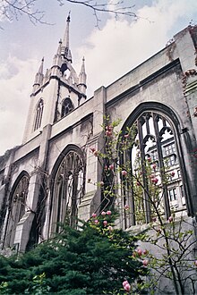
St Dunstan-in-the-East
| St Dunstan-in-the-East | |
|---|---|
 The site in 2010 | |
 | |
| Location | St. Dunstan's Hill London, EC3 |
| Country | United Kingdom |
| Denomination | Roman Catholic, Church of England |
| Website | Official City of London page |
| Architecture | |
| Heritage designation | Grade I |
| Architect(s) | Christopher Wren, David Laing |
St Dunstan-in-the-East was a Church of England parish church on St Dunstan's Hill, halfway between London Bridge and the Tower of London in the City of London. The church was largely destroyed in the Second World War[1] and the ruins are now a public garden maintained by the City of London Corporation.
History
[edit]
The church was originally built in about 1100. A new south aisle was added in 1391 and the church was repaired in 1631 at a cost of more than £2,400.[2]
It was severely damaged in the Great Fire of London in 1666.[3] Rather than being completely rebuilt, the damaged church was patched up between 1668 and 1671.[4] A steeple was added in 1695–1701 to the designs of Sir Christopher Wren. It was built in a gothic style sympathetic to the main body of the church, though with heavy string courses of a kind not used in the Middle Ages. It has a needle spire carried on four flying buttresses in the manner of that of St Nicholas in Newcastle.[5] The restored church had wooden carvings by Grinling Gibbons and an organ by Father Smith, which was transferred to the abbey at St Albans in 1818.
In 1817 it was found that the weight of the nave roof had thrust the walls seven inches out of the perpendicular. It was decided to rebuild the church from the level of the arches, but the state of the structure proved so bad that the whole building was taken down. It was rebuilt to a design in the perpendicular style by David Laing (then architect to the Board of Customs) with assistance from William Tite. The foundation stone was laid in November 1817 and the church re-opened for worship in January 1821. Built of Portland stone, with a plaster lierne nave vault, it was 115 feet long and 65 feet wide and could accommodate between six and seven hundred people. The cost of the work was £36,000. Wren's tower was retained in the new building.[5][6]
The church was severely damaged in the Blitz of 1941. Wren's tower and steeple survived the bombs' impact. Of the rest of the church only the north and south walls remained. In the re-organisation of the Anglican Church in London following the War it was decided not to rebuild St Dunstan's, and in 1967 the City of London Corporation decided to turn the ruins of the church into a public garden, which opened in 1971. A lawn and trees were planted in the ruins, with a low fountain in the middle of the nave. The tower now houses the All Hallows House Foundation.


The parish is now combined with the Benefice of All Hallows by the Tower and occasional open-air services are held in the church, such as on Palm Sunday prior to a procession to All Hallows by the Tower along St Dunstan's Hill and Great Tower Street. The ruin was designated a Grade I listed building on 4 January 1950.[7]
See also
[edit]- St Dunstan-in-the-West
- List of Christopher Wren churches in London
- List of churches rebuilt after the Great Fire but since demolished
References
[edit]- ^ Tucker, T. (2006). The Visitors Guide to the City of London Churches. London: Friends of the City Churches. ISBN 0-9553945-0-3.
- ^ Murray, Thomas Boyles (1859). Chronicles of a City Church, an account of the parish church of St. Dunstan in the East. London: Smith, Elder & Son. p. 10. Retrieved 22 October 2011.
- ^ "The City Churches" Tabor, M. p72:London; The Swarthmore Press Ltd; 1917
- ^ "The London Encyclopaedia" Hibbert,C; Weinreb,D; Keay,J: London, Pan Macmillan, 1983 (rev 1993,2008) ISBN 978-1-4050-4924-5
- ^ a b Bradley, Simon; Pevsner, Nikolaus (1998). London:the City Churches. The Buildings of England. London: Penguin Books. p. 80. ISBN 0-14-071100-7.
- ^ Murray, Thomas Boyles (1859). Chronicles of a City Church, an account of the parish church of St. Dunstan in the East. London: Smith, Elder & Son. p. 43. Retrieved 22 October 2011.
- ^ Historic England. "Details from listed building database (1359173)". National Heritage List for England. Retrieved 23 January 2009.
External links
[edit]- Information on St Dunstan Archived 14 March 2016 at the Wayback Machine
- BBC "Hidden gardens of the City" Facts
- Christopher Wren church buildings in London
- Parks and open spaces in the City of London
- Churches in the City of London, of which only the tower remains
- 17th-century Church of England church buildings
- Churches bombed by the Luftwaffe in London
- Ruins of churches destroyed during World War II
- Ruins in London
- Church ruins in England
- Grade I listed churches in the City of London
